

3 Cool Border Parks
City in Mexico
The U.S – Mexico border stretches for nearly 2000 miles, from Imperial Beach, California, to Brownsville, Texas. Along the way, the border is marked by walls, fences, and manned checkpoints. But more often, the border is invisible: a line existing only on maps, crossing deserts with names like Mojave, Sonoran, and Chihuahuan. This article describes three scenic parks on the border: Seminole Canyon State Park (Texas), Big Bend National Park (Texas), and Organ Pipe Cactus National Monument (Arizona).
Border Park 1 – Seminole Canyon State Park
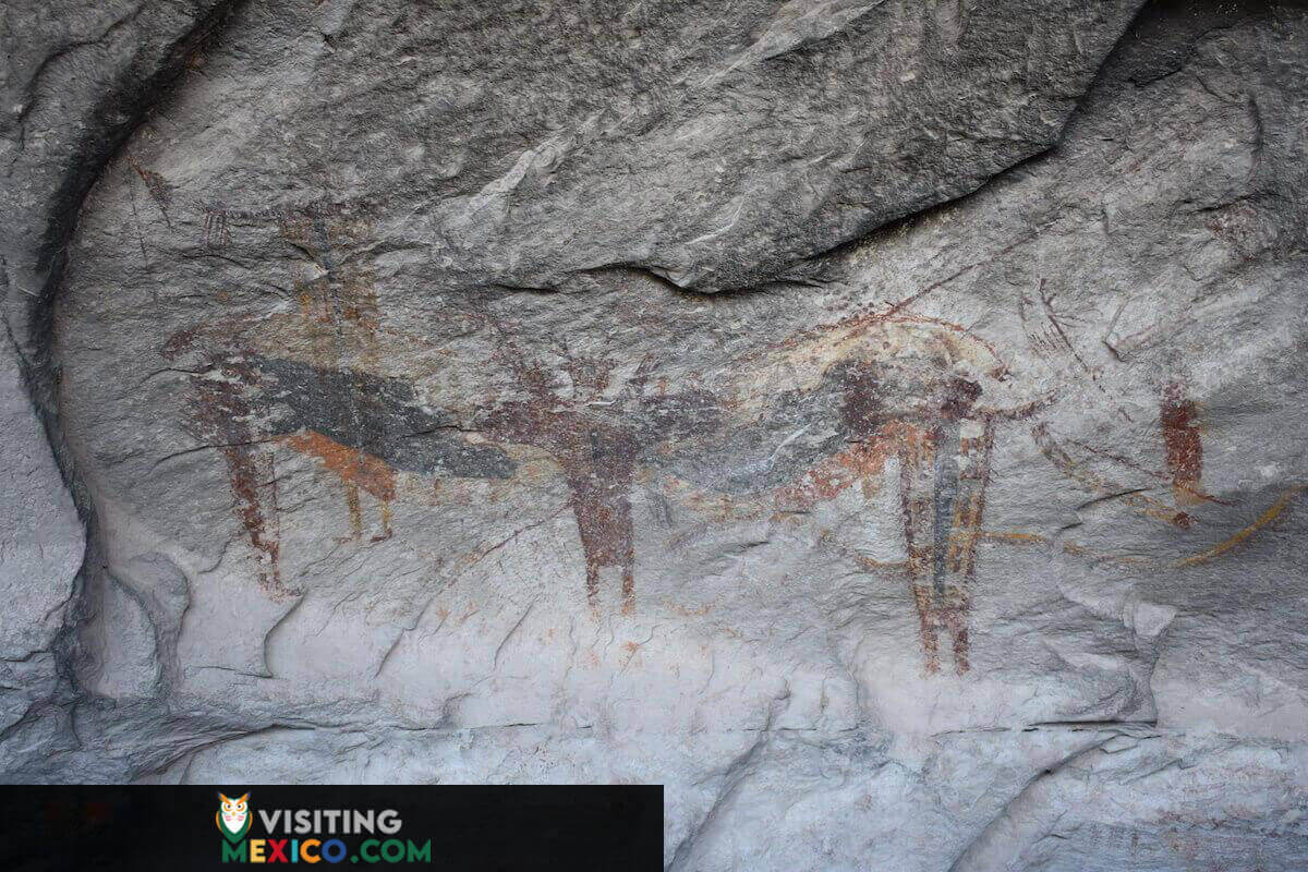
The Rio Grande marks the southern border for 900 miles, from El Paso, Texas, to the Gulf of Mexico. West of Del Rio, Texas, near the confluence of the Pecos River and the Rio Grande, is Seminole Canyon, State Park. The park’s main attractions are its numerous and elaborate prehistoric cave paintings (pictographs), some of the oldest in North America, dating back over 8000 years. Most pictographs can be viewed on a ranger-guided tour only, beginning at the park’s visitor center. The tour descends below the canyon rim, down a series of switchbacks, to a cave beneath a massive sandstone cliff overhang. The cave, known as Fate Bell Shelter, is adorned with colorful (and often haunting) images of snakes, human-like figures, and handprints.
Nearby Panther Cave, the region’s most famous pictograph site, can be reached only by boat from the nearby Amistad National Recreation Area. A 100-foot long panel of rock art, including a large panther, adorns the back wall of the cave.
The park also offers miles of scenic hiking trails. The aptly named Rio Grande Trail can be accessed from a parking lot near the Desert Vista Camping Area. The trail winds through the Chihuahuan desert: a rocky landscape dotted with cacti and home to deer, javelina bobcats, armadillos, and the rarely seen mountain lion. Along the way, offshoot trails lead to the rim of Seminole Canyon, with spectacular views of the river inlet below.
Rio Grande Trail End
The Rio Grande Trail ends at the banks of the legendary river itself. Here, you can stand amongst the rocks and look down upon the milky, coffee-colored waters of the Rio Grande. Directly to the east (several hundred yards away) is visible the confluence of the branch of the river that forms Seminole Canyon and the main branch of the Rio Grande. Beyond that, high limestone cliffs line the north bank of the river until it bends southward and out of view. The riverbank on the Mexican side, directly in front of the terminus of the Rio Grande Trail, is covered in lush green vegetation at water level, stretching back to a high rock shelf, beyond which lies more desert and the vast Mexican State of Coahuila.
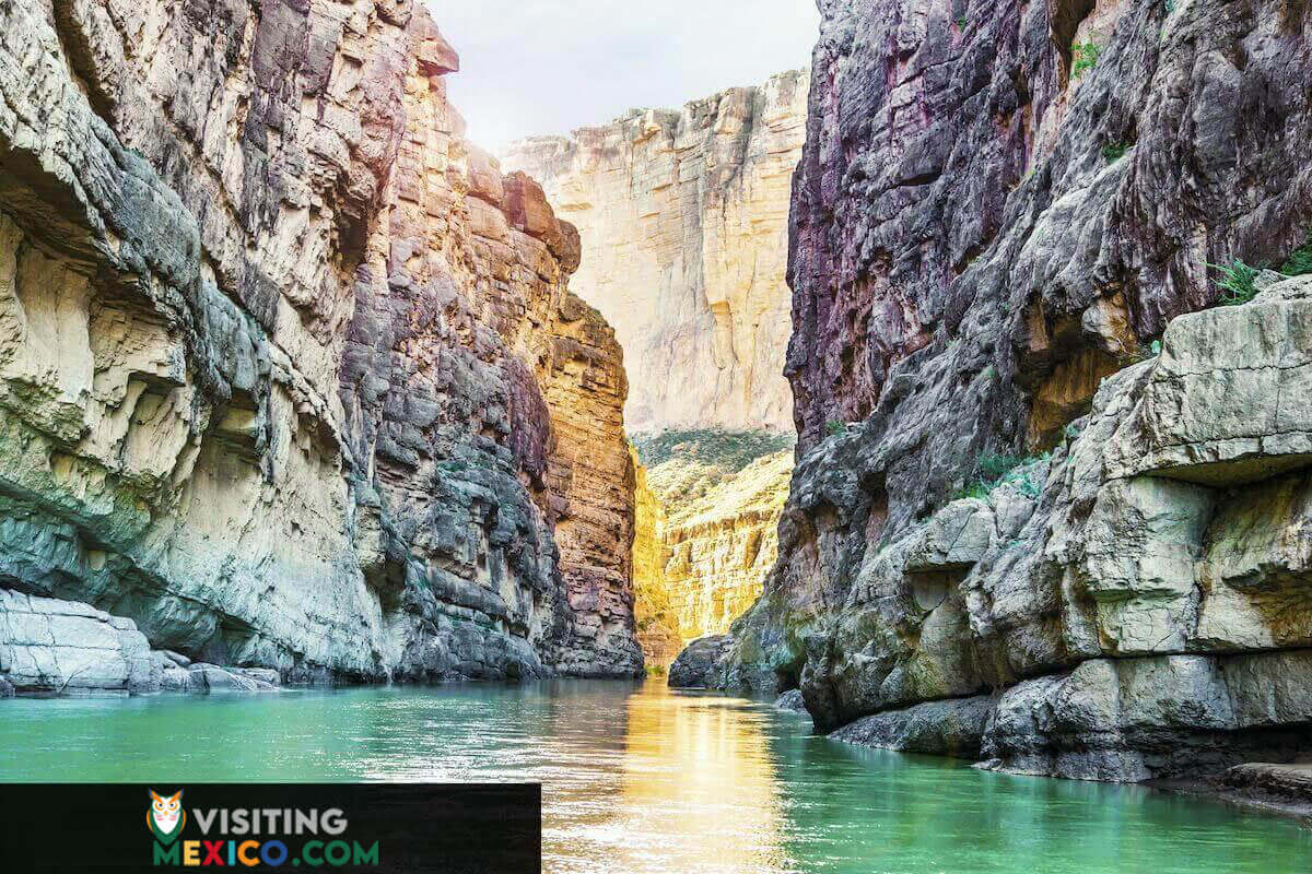
Border Park 2: Big Bend National Park
Tracing the Rio Grande’s path upstream from Seminole Canyon, the river dips south, forming a long “bend” before turning north again. Much of the land in between is part of Big Bend National Park. Big Bend is . . . big: it’s larger than the State of Rhode Island. And it’s remote. The park is hundreds of miles from the nearest big city, contributing to its status as one of the least visited in the National Park system.
To many visitors, this isolation is Big Bend’s greatest charm. It is a near-pristine landscape of striking canyons, gorges, mountains, and vast expanses of the Chihuahuan desert, in between 120 miles of twists and turns in the Rio Grande. Points of interest include Pine Canyon Falls, the dramatic Santa Ana Canyon (with the Rio Grande at its bottom), and the South Rim. But one spot at Big Bend is particularly unique: the Boquillas Border Crossing. Visitors can cross the river into the Mexican hamlet of Boquillas Del Carmen.
Big Bend Visitor Center
The U.S. Custom and Border Patrol’s Boquillas Crossing Point of Entry is located on the eastern edge of the park. Inside the adobe-like visitor center (open from May to October), would-be border crossers can present their passports and receive instructions on crossing into Mexico. From there, it is a short walk down to the river bank. For a few dollars, a small rowboat will ferry visitors across the river. When the river is low, the Border Patrol allows visitors to wade across, but if your plan includes getting lunch in Boquillas Del Carmen, the boat is a better option.
Upon reaching the opposite bank, you are in Boquillas del Carmen, Mexico. Almost. The village is a mile and a half away, through the desert. You can walk into town or for another small fee, ride a burro, a horse, or a truck. Before entering the tiny village of only a few hundred residents, you must pass through Mexican customs. You can then get a quick tour of the village (once a thriving mining town) with its lone church, dirt roads, and shops. The village’s two restaurants, which cater to tourists from Big Bend, offer tamales, chili Rellenos, tostadas, and other authentic Mexican fares. In the street, locals sell handmade jewelry and other trinkets. Beyond the edge of town, looming above, are the dramatic rock cliffs of the Sierras del Carmen mountains. After a few hours of visiting Boquillas, visitors can return the same way they came, crossing the river and re-entering through U.S. Customs, back into Big Bend.

Border Park 3: Organ Pipe Cactus National Monument
Moving west from Big Bend by 700 miles to Arizona’s southern border is the Organ Pipe Cactus National Monument. The monument was established in 1937 by FDR, to protect the multi-stemmed organ pipe cactus. The monument encompasses the northern edge of the organ pipe’s range: the only place in the U.S. where the nearly 20-foot tall cactus grows naturally. These giants bloom in May and June, offering up their large white flowers only at night to accommodate the bats that pollinate them.
While the organ pipe cacti are the monument’s namesake attraction, there are other natural wonders here. This vast piece of unspoiled Sonoran Desert is a U.N.E.S.C.O Biosphere Reserve. It is home to over 30 species of cacti, mountain lions, javelina, bighorn sheep, and many more. The monument is crisscrossed by a system of maintained dirt roads (most passable with a 2-wheel drive vehicle) leading through canyons with names like Diablo, Arch, and Estes, past abandoned mines, and up to the top of Ajo Mountain.
Organ Pipe is located 120 miles south of Phoenix. It is to the north by the tiny town of Why and to the south by the Mexican State of Sonora. Arizona Route 85 runs through the park, ending at the Border Patrol’s Lukeville Port of Entry. Through this small border crossing lies the City of Sonoyta, Mexico. But most Americans who cross here are not going to Sonyata: they are going to the beach. Just one hour and 15 minutes southwest of Lukeville is the popular Mexican beach resort town of Puerto Penasco (aka Rocky Point), on the Sea of Cortez.
Criminal Activity at Organ Pipe
Organ Pipe has had a troubled relationship with its 60 miles of the international border. After DEA crackdowns at larger cities along the border in the 1990s, smugglers began crossing in more remote areas. During this period park rangers and border patrol agents at Organ Pipe frequently intercepted drug smugglers working the monument. The situation escalated until tragedy struck. In 2002, National Park Ranger Kris Eggle died at the hands of the Mexican Cartel. Afterward, Organ Pipe was shut down to the public for over a decade.
In 2014 the entire monument open with better safety measures including surveillance, walls, fences, vehicle barriers, and additional law enforcement officers. While the monument is now safe for tourists, it remains a hazard for migrants. The heat, lack of water and sub-freezing night-time temperatures have led to all too frequent fatalities.
Organ Pipe was back in the news in the summer of 2019. At that time discussion surrounding a 30-foot high wall for this section of the border. Environmentalists are concerned about the effect such a barrier would have on wildlife. It seems as though the wall is coming to Organ Pipe.