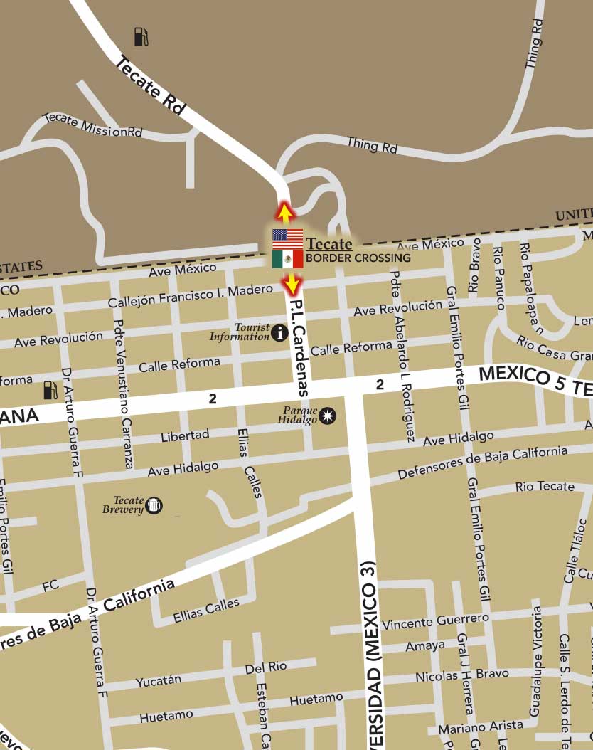
These Tecate maps and driving directions will provide you with an offline reference once you cross the border. Tecate is a city in Baja California, just across the border from Tecate, CA. Tecate is a favorite border crossing en route to Valle de Guadalupe, or San Felipe. Using the Tecate map, drivers can plan their trip and travel itinerary. The Tecate map also allows visitors to easily find landmarks throughout the city.

The trip from San Diego to Tecate takes roughly an hour and is just around forty miles. It’s a great alternative for those who want to visit Baja, without driving through Tijuana.
The trip from Phoenix to Tecate takes roughly five hours and is a 320-mile journey.
The Tecate map indicates that the journey is a relatively easy distance.
The Tecate offline map locates main thoroughfares, squares, and various city sections.
Tecate has a couple decent resorts and hotels. Many tourists who visit Tecate make a point to visit the historic brewery that produces Tecate Beer.
The Old Tecate Railroad Station also draws a crowd. For outdoor enthusiasts, the map can help locate exciting areas to enjoy hiking or horseback riding.
Because there are so many places in northern Mexico to get off the beaten track, a map of the region is essential. From mountain peaks to Native American sites to more scenic delights, Tecate is the ideal place to experience northern Mexico’s natural charms. The Tecate map can also help tourists locate hotels, inns, restaurants, shopping venues, and other historic and cultural attractions of the city. Be sure to consult the map if you decide to head beyond Tecate to other Baja California cities like Mexicali, Rosarito Beach, Tijuana, Puerto Nuevo, or Ensenada.
A form to capture the Coahuila interest in Trip Planning from the website.
A form to capture the Tamaulipas interest in Trip Planning from the website.
A form to capture the San Miguel de Allende interest in Trip Planning from the website.
A form to capture the Sinaloa interest in Trip Planning from the website.
A form to capture the Morelia interest in Trip Planning from the website.
A form to capture the Riviera Nayarit interest in Trip Planning from the website.
A form to capture the San Cristobal de las Casas interest in Trip Planning from the website.
A form to capture the Palenque interest in Trip Planning from the website.
A form to capture the Monterrey interest in Trip Planning from the website.
A form to capture the Nuevo Leon interest in Trip Planning from the website.
A form to capture the Hermosillo interest in Trip Planning from the website.
A form to capture the San Carlos interest in Trip Planning from the website.
A form to capture the Puerto Peñasco interest in Trip Planning from the website.
A form to capture the Sonora interest in Trip Planning from the website.
A form to capture the Mexico City interest in Trip Planning from the website.
A form to capture the Ciudad Juarez interest in Trip Planning from the website.
A form to capture the Chihuahua interest in Trip Planning from the website.
A form to capture the Los Cabos interest in Trip Planning from the website.
A form to capture the Todos Santos interest in Trip Planning from the website.
A form to capture the Loreto interest in Trip Planning from the website.
A form to capture the Baja Sur interest in Trip Planning from the website.
A form to capture the Tijuana interest in Trip Planning from the website.
A form to capture the Mexicali interest in Trip Planning from the website.
A form to capture the Tecate interest in Trip Planning from the website.
A form to capture the Puerto Nuevo interest in Trip Planning from the website.
A form to capture the Valle de Guadalupe interest in Trip Planning from the website.
A form to capture the Ensenada interest in Trip Planning from the website.
A form to capture the Rosarito interest in Trip Planning from the website.
A form to capture the San Felipe interest in Trip Planning from the website.
A form to capture the Baja California interest in Trip Planning from the website.
Form signup from a conference to retrieve business details of people in Mexico who have business that would like to be affiliated with our website for marketing and advertising purposes.
"*" indicates required fields