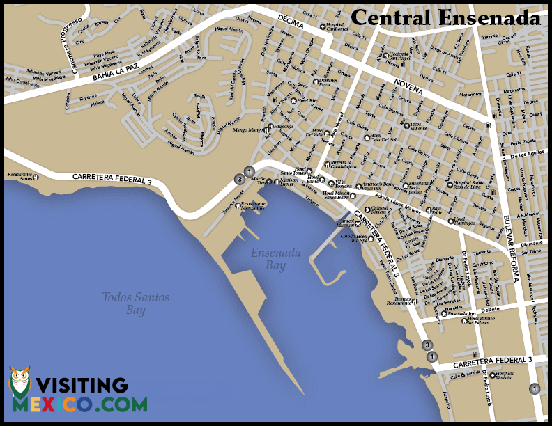
Ensenada Map
Bringing Pets to Mexico
City in Mexico
Called the “Cinderella of the Pacific,” the Mexican city of Ensenada is located in the state of Baja California on a gorgeous stretch of the Pacific coast. When viewed on the Ensenada map, the city is ideally located on the Baja Peninsula and is a popular cruise ship port as well as a renowned vacation destination. Whether driving or flying into the city, the Ensenada map can help travelers locate accommodations, restaurants, cultural venues, scenic attractions, and even historical sites outside the city.

Tijuana to Ensenada Driving Directions
Many travelers to Mexico head into the nation via Tijuana. The drive from Tijuana to Ensenada is a pleasant one and takes less than an hour and a half. Once in Tijuana, drivers should take the Playas de Tijuana Road or the Tijuana-Ensenada Toll Road. The route is known for its majestic Pacific view. Drivers should be prepared to pay three tolls along the way at $2.10 U.S. each. The scenic highway is an extraordinary drive; however, drivers will note from the Ensenada map that there is an alternate route without toll roads that may be driven from Tijuana to Ensenada as well. Keep in mind that the toll road, however, features the Green Angels who patrol the highway to help drivers who may have broken down or need automatic help of some sort.
Tecate to Ensenada Driving Directions
The drive from the lovely mountain city of Tecate down to Ensenada takes slightly more than an hour and a half. Drivers should travel west on Carretera Federal 2/Mexico 2/Tecate–Tijuana going toward Libertad. Merge slightly right onto Corredor Tijuana 2000. Then, merge onto K1. Turn left on Ensenada-Tijuana (Libre)/Tijuana-Ensenada/Carr Federal 1/Mexico 1. Take a slight right on Escenica Tijuana/Ensenada. Continue driving on Tijuana-Ensenada/Carr Federal 1/Mexico 1. Make a left on Riveroll and then right on Novena. Continue on 9. Make a right on Jose Maria Morelos y Pavon. Finally, turn left on Coral and head into town.

Traveling around Ensenada
Using the Ensenada map, drivers can see that Ensenada truly has much to offer vacationers. Various beaches and beautiful scenic attractions in the city give way to regional attractions. Many visitors to Ensenada like to travel outside the city as well to such areas as Valle de Guadalupe to visit the peninsula’s famous vineyards and wineries. The Baja Peninsula also boasts many extraordinary historic sites from cave paintings to missions.
When vacationing in the city, travelers can use the Ensenada map to explore major thoroughfares and discover some of Ensenada’s best restaurants and shopping venues. The map can help visitors to Ensenada locate hotels, campgrounds, areas for off-roading, and specific beaches. Ensenada is a beautiful coastal city that draws traffic from around the globe. It’s the perfect place to experience all the best of Mexico.


