

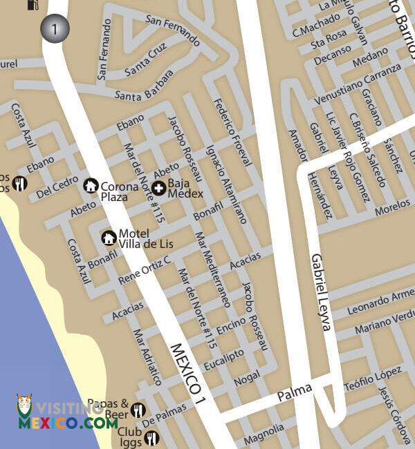
This Rosarito maps page and Rosarito driving directions will help you get to and enjoy your stay in Rosarito. Rosarito’s various locales and geography are amazing to enjoy so why is waste time getting lost? Travelers will easily locate direct routes to the city from other Baja California destinations like Tijuana, Ensenada, and other peninsula cities. Upon crossing the U.S. border into Mexico, check out the Rosarito Map to make traveling through Mexico accurate and efficient.
If you check out the Rosarito map, you’ll see that Rosarito is just a short distance from Tijuana. In fact, before it became a city in its own right, Rosarito was part of the Tijuana greater Metropolitan area. In less than thirty minutes, you can drive from Tijuana to Rosarito Beach. From San Diego, it will take slightly less than an hour—about forty-five to fifty minutes. Head to the San Ysidro border crossing on Highway 5 or Interstate 805 South. After crossing into Mexico, head right toward the Rosarito-Ensenada Scenic Road.
Taking the scenic toll road is quicker and considered the preferable route among tourists due to the ocean views and Green Angels, mobile mechanics, who patrol the roads there. The toll costs $2.40 U.S. dollars. After bearing right, you should choose the route marked Playas de Tijuana Rosarito. You’ll travel west and after dropping into the canyon known as Smugglers Canyon, you’ll want to go right on the turn-off labeled Ensenada Quota. Once you pay the toll on this road, you’ll keep traveling straight into Rosarito. Check the Rosarito map to help you locate specific thoroughfares in Rosarito taking you to specific city sites and addresses.
Many travelers fly into Ensenada to experience all its vacation charms, but many love to get out of the city to drive up the beautiful coast to Rosarito. The trip is scenic and only takes about an hour. There are various car rental agencies in Ensenada and the hotels can help you locate one nearby. Using the Rosarito map, take the Bulevar Reforma north toward Cortes. Merge left onto Av Benito Juarez / Calle Benito Juarez / Calle Quinta and then make a right onto Juan Aldama. Go right again on Adolfo Lopez Mateos and then left on Av Riveroll. Your first right will take you to Mexico 1 and then to Enscenica Ensenada-Tijuana. You’ll continue to follow this route until reaching Palma where you’ll take a right. You’ll next need to make a left to continue on Palma and you’ll take this straight into Rosarito.
By checking out the Rosarito map, you can also locate other routes to more scenic Baja California destinations like Tecate or Mexicali. The map will also help you navigate the streets of Rosarito to locate the cultural attractions you want to see. The map can also help you find exciting venues near your hotel. Rosarito may not be as large as Tijuana, but it has an immense amount of things to do, places to visit, and even restaurants to enjoy. Check with your hotel to learn about nearby attractions and use the map to help you easily find them.

A form to capture the Coahuila interest in Trip Planning from the website.
A form to capture the Tamaulipas interest in Trip Planning from the website.
A form to capture the San Miguel de Allende interest in Trip Planning from the website.
A form to capture the Sinaloa interest in Trip Planning from the website.
A form to capture the Morelia interest in Trip Planning from the website.
A form to capture the Riviera Nayarit interest in Trip Planning from the website.
A form to capture the San Cristobal de las Casas interest in Trip Planning from the website.
A form to capture the Palenque interest in Trip Planning from the website.
A form to capture the Monterrey interest in Trip Planning from the website.
A form to capture the Nuevo Leon interest in Trip Planning from the website.
A form to capture the Hermosillo interest in Trip Planning from the website.
A form to capture the San Carlos interest in Trip Planning from the website.
A form to capture the Puerto Peñasco interest in Trip Planning from the website.
A form to capture the Sonora interest in Trip Planning from the website.
A form to capture the Mexico City interest in Trip Planning from the website.
A form to capture the Ciudad Juarez interest in Trip Planning from the website.
A form to capture the Chihuahua interest in Trip Planning from the website.
A form to capture the Los Cabos interest in Trip Planning from the website.
A form to capture the Todos Santos interest in Trip Planning from the website.
A form to capture the Loreto interest in Trip Planning from the website.
A form to capture the Baja Sur interest in Trip Planning from the website.
A form to capture the Tijuana interest in Trip Planning from the website.
A form to capture the Mexicali interest in Trip Planning from the website.
A form to capture the Tecate interest in Trip Planning from the website.
A form to capture the Puerto Nuevo interest in Trip Planning from the website.
A form to capture the Valle de Guadalupe interest in Trip Planning from the website.
A form to capture the Ensenada interest in Trip Planning from the website.
A form to capture the Rosarito interest in Trip Planning from the website.
A form to capture the San Felipe interest in Trip Planning from the website.
A form to capture the Baja California interest in Trip Planning from the website.
Form signup from a conference to retrieve business details of people in Mexico who have business that would like to be affiliated with our website for marketing and advertising purposes.
"*" indicates required fields