Baja Surf Map
Download the Baja Surf Map and plan your surf road trip from Rosarito and Ensenada to Seven Sisters, Scorpion Bay, Cerritos, and beyond.
Send Me the Baja Surf MapPlan Your Baja Surf Route
Baja is one of North America’s classic surf-road-trip destinations, with point breaks, beach breaks, reef breaks, remote camp spots, and border-close waves that make the peninsula a favorite for surfers traveling south from California.
This free Baja Surf Map PDF gives you a visual overview of many of the peninsula’s best-known surf zones, including northern Baja breaks near Rosarito and Ensenada, remote Pacific Coast surf zones farther south, and legendary Baja California Sur destinations.
Use the full Baja Surf Guide alongside this map for more trip-planning context, route ideas, and surf spot notes.

Get the Baja Surf Map PDF in Your Inbox
Save the map before your trip so you can reference Baja surf zones while planning your route, even when cell service is limited on remote stretches of the peninsula.
Download the Free MapWhat’s on the Map?
The Baja Surf Map highlights a wide range of surf areas across the peninsula, from easy-to-reach northern Baja beaches to remote Pacific Coast destinations that require more planning, supplies, and driving time.
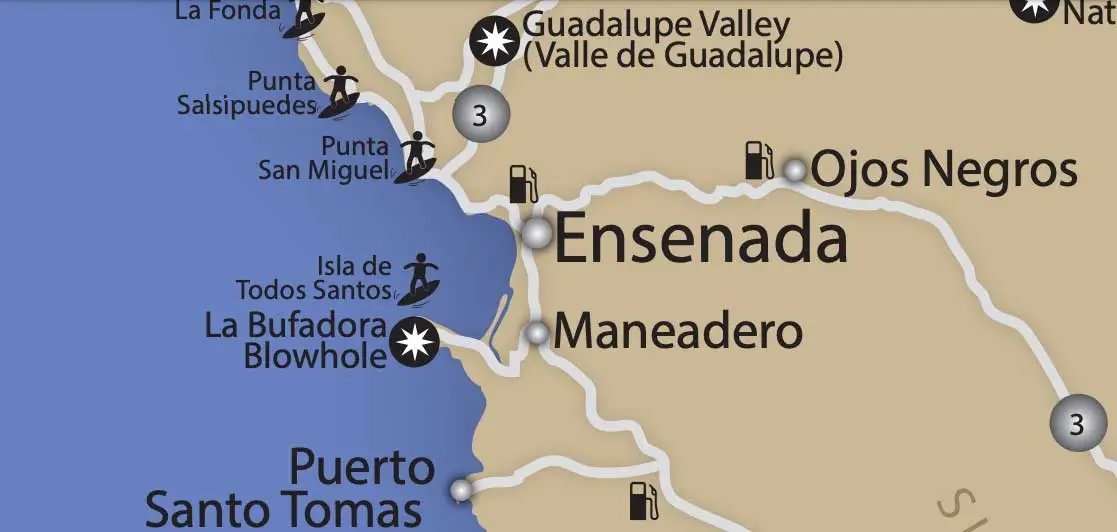
Northern Baja Surf
Rosarito, Calafia, San Miguel, Salsipuedes, La Fonda, and the Ensenada-area breaks are popular with surfers because they are relatively close to the U.S. border and can fit into shorter Baja surf trips.
Remote Pacific Coast Routes
Farther south, Baja becomes more rugged and remote. Zones like Seven Sisters, Punta Baja, Punta San José, and Scorpion Bay reward prepared travelers with classic Baja surf-trip scenery and longer adventure routes.
Baja California Sur Breaks
Surf destinations around Todos Santos, Playa Los Cerritos, Los Cabos, and East Cape routes offer warmer-weather surf-trip options, especially for travelers combining surf with beach towns and longer Baja vacations.
Use the Map With the Baja Surf Guide
The map is best used as a quick visual planning tool. For a deeper overview of Baja surf regions, routes, and travel notes, visit the full Baja Surf Guide.
The guide gives you more context, while this map helps you visualize how the surf spots line up along the peninsula.
Driving to Baja With Surfboards?
Most Baja surf trips start with a border crossing. Before you load the boards and head south, make sure you have the essentials covered: Mexico auto insurance, border documents, route planning, and basic driving rules.
U.S. insurance is not recognized by Mexican authorities for liability you cause while driving in Mexico. At minimum, drivers should carry Liability Only coverage from a Mexican insurance company.
Download the Free Baja Surf Map
Have the Baja Surf Map delivered instantly to your inbox and keep it handy while planning your route down the peninsula.
Send the Map to My InboxBaja Surf Map FAQ
Is the Baja Surf Map free?
Yes. You can request the Baja Surf Map PDF and have it delivered to your inbox for free.
Does the map replace the full Baja Surf Guide?
No. The map is a quick visual reference. The Baja Surf Guide is the better page for broader trip planning, surf regions, and route context.
What areas are included on the Baja Surf Map?
The map highlights surf areas across Baja California and Baja California Sur, including northern Baja breaks near Rosarito and Ensenada, remote Pacific Coast zones, and southern Baja surf destinations.
Do I need separate insurance to drive to Baja surf spots?
Yes. Even if a U.S. carrier says your vehicle has some coverage in Mexico, U.S. insurance is not recognized by Mexican authorities for damage you cause while driving in Mexico. At minimum, travelers should carry Liability Only coverage from a Mexican insurance company. Learn more in our Mexico driving laws guide, or get a quote from GoBuho.com.